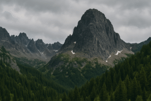
Mount Gessi, named after Italian explorer Romulo Gessi who helped map out parts of Africa during the 1800’s, is nestled in the heart of the Rwenzori Mountains National Park and boasts the 11th highest peak in Africa (Lolanda). Sitting on the border between Congo and Uganda it sits at a generous 4,715 metres high with a prominence of 565 metres. The mountain is located in Bugendere in the Western Region of Uganda, and is surrounded by lush forest, and filled with fascinating flora, fauna and vegetation. It is also surrounded by huts and homes in the surrounding Bakonzo Villages.
Though it isn’t as famous as Margherita Peak, Mount Gessi offers amazing views, peaceful hiking routes, and a chance to see rare plants and animals. The mountain is filled with life, from colorful birds like the Rwenzori turaco to black-and-white colobus monkeys. A hike through the forest, fascinating plantlife unique to the area. Though it has lost it’s status as an icy peak, you can still see traces of the glaciers that were once there.
Where can I find a map of Mount Gessi?
If you want a map that shows Mount Gessi clearly, you’ll need to look at special hiking maps for the Rwenzori Mountains. These are usually shared by national park rangers or given out by tour guides who take people up the mountains. Gessi is close to another mountain called Emin, and hikers often get to it by first going through the Mugusu Valley. Online maps might not show it clearly, but your trekking guide will likely have a proper map that shows the trail, the valleys, and nearby landmarks.
What is the weather like on Mount Gessi?
The weather around Mount Gessi is very unpredictable. Even during the dry season, it can be rainy, cold, and foggy. The bottom of the mountain, may feel warm and humid, getting colder the higher you go, especially at night. The best months to hike are from June to September and then from December to February due to reduced rain and better trail conditions. However, it’s important to bring warm clothes, rain jackets, and strong boots to stay safe and comfortable while visiting Mount Gessi during any period.
What other mountains can I visit in Uganda?
Uganda is home to a diverse range of mountains, each offering unique landscapes and experiences for hikers and nature lovers. The most iconic range is the Rwenzori Mountains, often referred to as the “Mountains of the Moon.” Here, snow-capped peaks like Margherita, Speke, and Baker attract seasoned trekkers seeking dramatic scenery, alpine vegetation, and a true backcountry adventure through dense forests, glacial rivers, and rare wildlife habitats.
For those interested in a less demanding climb, Mount Elgon, located on the eastern border with Kenya, offers wide open trails, striking waterfalls, and one of the world’s largest volcanic calderas. Its gentler slopes make it accessible to more casual hikers while still providing breathtaking views and biodiversity.
In the southwestern part of the country, the Virunga Volcanoes present a different kind of experience. These forested volcanic peaks—such as Mount Muhabura and Mount Sabinyo—are not only known for their scenic beauty, but also for their role in protecting the critically endangered mountain gorillas. Treks here often combine volcanic hiking with the chance to observe these incredible animals in their natural habitat.
Whether you’re after high-altitude glacier treks, scenic volcanic slopes, or immersive rainforest hikes, Uganda’s mountains offer a variety of landscapes suited to both adventure seekers and nature enthusiasts alike.